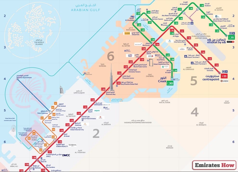
Dubai Metro Map 2025 for Travelers Guidance

The Dubai Metro system gives passengers an efficient cheap travel option that connects customers to essential locations including business centers shopping malls and tourist sites. This comprehensive guide explains the features of Dubai Metro including its operational lines plus their station stops as well as operational time periods.
Table of Contents
Dubai Metro Map
The metro system is a vital part of Dubai’s public transport network, offering a convenient and comfortable travel option for both residents and visitors. You can see the map details in the following image:

Dubai Metro Lines
Several important lines of the Dubai Metro system connect the city for essential transportation needs. The following section outlines all information related to Dubai Metro Lines and their corresponding routes:
| Metro Line | Length | Number of Stations | Route | Major Stations |
|---|---|---|---|---|
| Red Line | 52.1 km | 35 stations | Al Rashidiya Station to Jebel Ali Station | Centrepoint, Emirates, Airport Terminal 3, Airport Terminal 1, GGICOCity, Centre Deira, Al Rigga, Union, Burjuman, ADCB, Max, World Trade Center, Emirates Towers, Financial Centre, Burj Khalifa/Dubai Mall, Business Bay, ONPASSIVE, Equiti, Mall of the Emirates, Mashreq, Duba, Internet City, Al Khail, Sobha Realty, DMCC, Jabal Ali, Ibn Battuta, Energy, Danube, UAE Exchange. |
| Green Line | 22.5 km | 20 stations | Etisalat Station to Al Khor Station | Etisalat by e&, Al Qusais, Dubai Airport Free Zone, Al Nahda, Stadium, Al Qiyadah, Abu Hail, Abu Baker Al Siddique, Salah Al Din, Union, Baniyas Square, Gold Souq, Al Ras, Al Gubaiba, Sharaf DG, Burjuman, Oud Metha, Dubai Healthcare City, Al Jadaf, Creek. |
| Blue Line | 14.5 km | 7 stations | – | (Upcoming) – Expected stations yet to be announced |
Dubai Metro Map PDF
The official website of the Roads and Transport Authority (RTA) offers travelers to access and download both interactive and downloadable copies of the Dubai Metro Map. The Dubai Metro Map PDF “From Here” offers a comprehensive documentation about metro lines and stations together with routes and every significant details. .
Tips for Travelers Using the Dubai Metro
The following guidelines will help you utilize the Dubai Metro Map more effectively during your next journey:
- The Dubai Metro Map allows users to plan ahead their travel routes before they embark. The map will assist you in identifying which line, together with the station, gives you the quickest route to your destination.
- Travel during off-peak hours because this time period offers fewer passengers for a more comfortable and less crowded journey. Travelling during rush periods will yield increased train service frequencies.
- The NOL Card functions as an easy payment method through its smart contactless card features that cover metro fares. You can acquire and recharge the NOL card at all metro stations. An NOL card provides quicker payment and added convenience when compared to separate tickets.
- To maintain real-time access to train schedules, together with station updates and service disruptions, you should refer to the official RTA website or mobile app. This practice helps prevent schedule delays.
Benefits of Using Dubai Metro
The Dubai Metro benefits its passengers through multiple conveniences that attract residents alongside visitors.
- The Dubai Metro provides maximum efficiency because its high-frequency trains, combined with their speed, allow you to arrive at your destination before you would by car.
- The metro system serves as an affordable form of transportation because it provides different payment plans for those who use the system occasionally or regularly.
- The metro system helps decrease road-based transportation, which leads to reduced environmental emissions and improved air quality.
- The Dubai Metro serves all ability levels because it provides elevator access and escalator service along with defined disabled-friendly areas throughout the system.
Conclusion
Residents and visitors of Dubai depend on the Dubai Metro Map to guide their transportation through Dubai’s expanding public transit system. The metro expands its services through more lines and stations while delivering sophisticated amenities.
Questions & Answers
The Dubai Metro Map shows the routes, stations, and connectivity of the metro lines across the city.
There are currently two main operational lines, the Red Line and Green Line, with the Blue Line expected in 2029.
The Dubai Metro operates from 5:00 AM to midnight on most days, with extended hours on Fridays.
Stations are well-marked with signage and digital maps, making navigation easy for passengers.
Yes, the Dubai Metro timings are available on the official Roads and Transport Authority (RTA) website and mobile app.
Key stations on the Red Line include Al Rashidiya, Jebel Ali, Burj Khalifa/Dubai Mall, and Mall of the Emirates.
No, the Blue Line is expected to open in 2029.
Yes, you can use a NOL card to pay for your metro journey.
The metro runs every 5 minutes during weekends, 7 minutes during off-peak hours, and every 3 minutes 45 seconds during peak hours.
Yes, the Dubai Metro helps reduce traffic congestion and lower carbon emissions.
